 Plotlay
Menu
Put the drawing
on the ground.
Start now · free · no sign-up
Design a room →A furnished bedroom, living room, kitchen, bathroom, office, shop or gym in 3D, in a few taps Put a plan on a map →Line a floor plan, site plan or PDF up on the aerial, to scaleOr start with a whole house · rooms from your drawings · a garden · a car park
Line any plan up on the aerial at its true size, design rooms to the centimetre and walk through them in 3D, then issue scaled drawings, quotes and site audits. No CAD licence, nothing to install.
Or keep your work in an account (free, no card):
Every tool is on the free plan. Or open the full app.
 every column lands on the real colonnade
pinned at the 4 terrace corners · RMS 0.03 m
What you can do with it
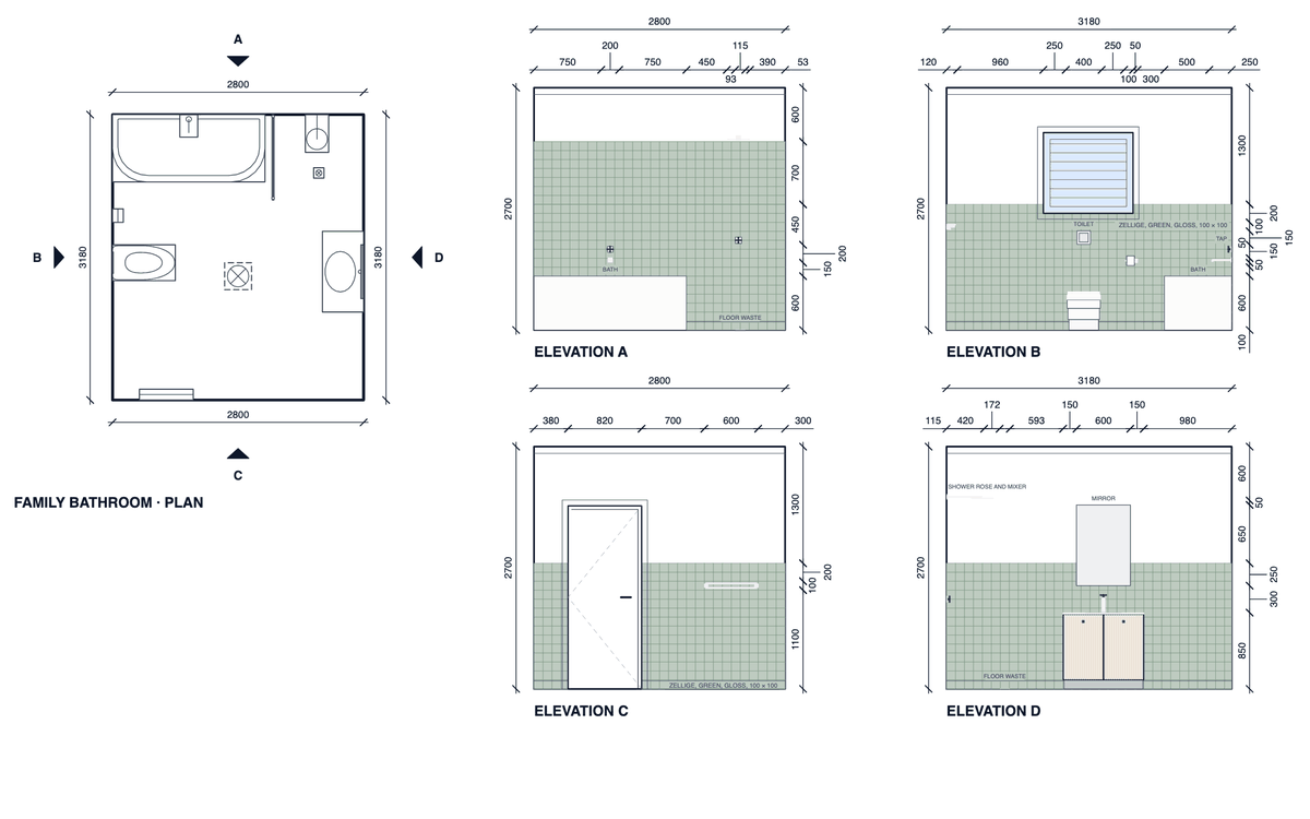
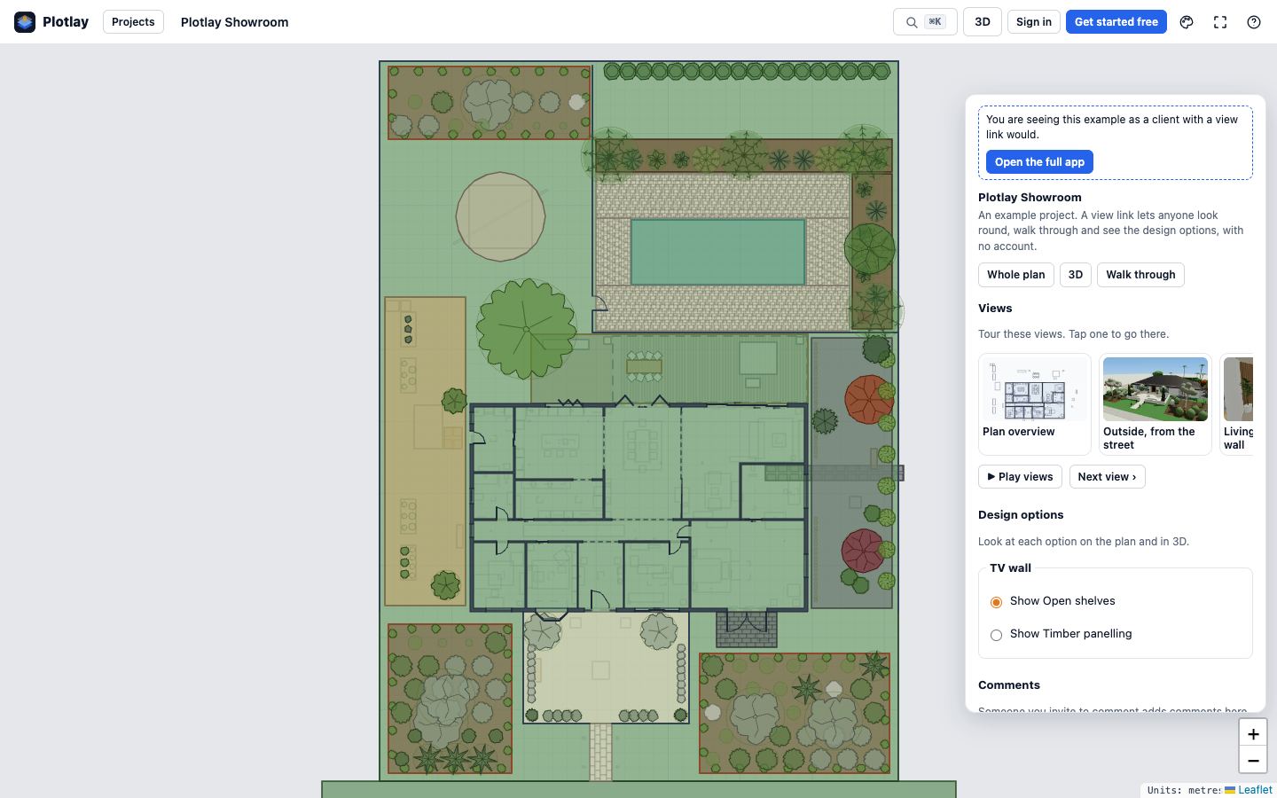
Try it in 5 minutes
- Pick a startAnswer a few questions: the room, its size, the door and window, a look. Plotlay lays it out. A roomA houseFrom drawingsPlan on a mapA gardenA car park
- Change anythingTap a piece to move it, change it or take it out. Try another layout, swap the tiles, add what it still needs.
- See it, send itWalk through it in 3D, make a photo, or share a link that opens where you choose. Keep it with a free account, no card.
Who it’s for
Get started with your agent
Work with Claude, ChatGPT or another AI agent? Paste one prompt into it: it connects to Plotlay with you, step by step, then works in your projects.
- Draw rooms, walls, doors and windows from sizes you give it.
- Place fit-out and furniture, set finishes, roofs and site facts.
- Check a design against the codes and say what still needs measuring.
- Price a job, make a quote, and produce plans, elevations and room packs.
Everything it does is an ordinary Plotlay project: open it, check it, change it by hand. It acts as you and sees only your projects.
What the connector can do →
Connection guide for Claude, ChatGPT and others →
Help me connect Plotlay to you, then get started. Read https://www.getplotlay.com/agents/connect (plain text: https://www.getplotlay.com/agents/connect.md) and walk me through connecting the Plotlay connector step by step, for the app I'm using you in. If you can't open web pages: Plotlay's connector is a remote MCP server at https://app.plotlay.io/mcp, and I sign in to Plotlay when I connect it, so there is no key to copy. Tell me where to add a custom connector in this app. When it's connected, list my Plotlay projects and suggest a good first task.
Help me connect Plotlay to you, then get started. Read https://www.getplotlay.com/agents/connect (plain text: https://www.getplotlay.com/agents/connect.md) and walk me through connecting the Plotlay connector step by step, for the app I'm using you in. If you can't open web pages: Plotlay's connector is a remote MCP server at https://app.plotlay.io/mcp, and I sign in to Plotlay when I connect it, so there is no key to copy. Tell me where to add a custom connector in this app. When it's connected, help me put my floor plan on the map: ask for the address and the plan, start a project there, and tell me which steps I do in the Plotlay app myself.
Help me connect Plotlay to you, then get started. Read https://www.getplotlay.com/agents/connect (plain text: https://www.getplotlay.com/agents/connect.md) and walk me through connecting the Plotlay connector step by step, for the app I'm using you in. If you can't open web pages: Plotlay's connector is a remote MCP server at https://app.plotlay.io/mcp, and I sign in to Plotlay when I connect it, so there is no key to copy. Tell me where to add a custom connector in this app. When it's connected, help me price a job and make a quote: ask which project and rooms (or help me draw them first), estimate it with my rates, and show me the quote before anything is sent.
Paste it into Claude, ChatGPT or another AI agent. It reads the connection guide, walks you through connecting the Plotlay connector in the app you use it in, then lists your projects and suggests a first task.
Connector URL https://app.plotlay.io/mcp
You need a Plotlay account (free is fine): the agent signs in as you and works only in the projects you can.
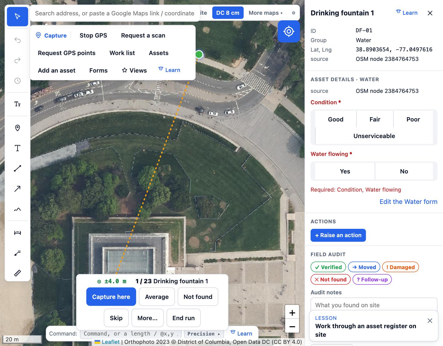
A work list on the phone
An example audit of the park furniture around the Lincoln Memorial: 20 benches, bins and fountains to verify and 3 entries with no coordinates to locate.


Guide: verify an asset register on site →
Measure the rooms with Plotlay Scan. The free companion app measures each room with LiDAR on an iPhone Pro or iPad Pro, or by tapping the floor corners on other iPhones, iPads and Android phones, and sends it to your project at its measured size. About Plotlay Scan →


The tools are free. The cloud is what costs.
| Free | Project pass | Pro | Team | |
|---|---|---|---|---|
| Price | $0 | $29once · 30 days | $29per month, or $288 a year | $99per month · 5 people +$19 per extra person |
| Every tool & export | ● | ● | ● | ● |
| Projects in the cloud | 3 | for 30 days | unlimited | unlimited, shared |
| Sharing | 3 view links per projectup to 14 days each | unlimited view links2 guest editors | unlimited view links3 guest editors | unlimited view linksmembers, plus 5 guest editors |
| Print quality renderscloud credits | 5 to try | 15 a month | 40 a month | 120 a monthshared by the team |
| Your logo, team space | ○ | ○ | logo | logo, team space, roles |
| Open app | Get a pass | Go Pro | Start a team |
Free
Every tool and export · estimates and quotes · your own finishes and objects · the AI connector · 3 cloud projects · 3 view links (14 days each) and 5 comment guests per project · documents shared with 3 people for up to 7 days · 5 Print quality renders to try
Open appProject pass
Cloud projects for 30 days · unlimited view links · 10 comment guests and 2 guest editors per project · 1 connected copy · documents shared with 10 people for up to 30 days · 15 Print quality credits a month
Get a passPro
Unlimited cloud projects · unlimited view links · 10 comment guests and 3 guest editors per project · 3 connected copies · documents shared with 25 people · your logo on plan sheets and quotes · 40 Print quality credits a month
Go ProTeam
Shared projects and registers · a team library of finishes and objects · invites and roles · unlimited comment guests · 5 guest editors across the team · unlimited connected copies · documents shared with 50 people · 120 Print quality credits a month, shared by the team
Start a teamCompare everything
| Free | Project pass | Pro | Team | |
|---|---|---|---|---|
| Every tool & export | ● | ● | ● | ● |
| Projects in the cloud | 3 | for 30 days | unlimited | unlimited, shared |
| View links | 3 per projectup to 14 days, small Plotlay mark | unlimited | unlimited | unlimited |
| People who view or comment | 5 per project | 10 per project | 10 per project | unlimited |
| Guest editors | with their own Pro plan | 2 per project | 3 per project | members, plus 5 guests |
| Connected copies | ○ | 1 | 3 | unlimited |
| Shared documents | 3 people each, up to 7 days | 10 people, up to 30 days | 25 people, no time limit | 50 people, no time limit |
| AI connector | ● | ● | ● | ● |
| Estimates and quotes | ● | ● | ● | ● |
| Your own finishes and objects | ● | ● | ● | ●plus a team library |
| Print quality renderspaid add-on, in credits | 5 to try | 15 a month | 40 a month | 120 a monthshared by the team |
| Your logo on sheets and quotes | ○ | ○ | ● | ● |
| Team space, invites, roles | ○ | ○ | ○ | ● |
Renders: free on your own computer, or fast in the cloud
On your own hardware, free. Photo render traces the light on your own computer, on every plan including Free. A recent graphics card makes a good picture in a few minutes; a slower one takes longer, and it carries on in the background while you work.
In the cloud, with credits. Print quality sends the same view to a cloud graphics card and renders it in Blender Cycles in a few minutes, clean enough to print. It carries on with Plotlay closed: the picture goes into Documents and you get an email when it is done.
1 credit = one Full HD render. Larger sizes and High quality use more.
| Size | Standard | High |
|---|---|---|
| Full HD, 1920 × 1080 | 1 | 2 |
| 4K, 3840 × 2160 | 2 | 4 |
| A3 at 150 dpi | 2 | 3 |
| A3 at 300 dpi | 4 | 8 |
Credits each month: Project pass 15, Pro 40, Team 120 shared by the team. A free account has 5 to try. Unused monthly credits don't carry over. Top-up packs on any plan: $9.90 for 20 Print quality credits, and top-up credits never expire. The app shows the credits a render uses, and how many you have left, before it starts. A render that fails, or that you cancel, gives its credits back.
 Outside, from the street
 A Quick start bedroom
 Kitchen
Print quality renders, 1920 × 1080: the Showroom example and a bedroom from Quick start. Tap one to see it full size.
Design ideas (beta): AI pictures of a room in another style, made from your render, each with the changes it suggests and what Plotlay has for them, to add as a new design option. Ideas are AI generated and may differ from your design. A free account has 4 idea pictures a month; Project pass 10, Pro 20 and Team 60 (more).
Whoever shares pays for it. People you share with need only a free account to comment, pick design options and accept a quote, and a project shared with them never counts against their own limit. Anyone with a view link can look round without an account. A guest with their own Pro or Team plan edits without using your guest editor places.
Cancel any time and keep the plan to the end of the period. Prices in AUD, including GST where it applies. Need SSO, your own imagery or a private deployment for a larger organisation? Talk to us.
Outside Australia? Prices are in Australian dollars: your bank converts them, Stripe’s payment page shows the amount before you pay, and businesses can add a tax ID for their invoices. Maps, plans, 3D, drawings, field capture and Plotlay Scan work anywhere. Design code packs cover Australia and New Zealand in depth, England, Ireland, the US and Canada for stairs, doors, escape windows and access, and some rules in France, Spain, Germany, Scotland, Wales and Singapore (every pack and its source); packs for other places can be written in the same rule-pack format. Support is run from Adelaide, South Australia (UTC+9:30, or +10:30 in summer). In the EU, EEA or UK, read your consumer rights and your privacy rights; for business customers there is a data processing addendum.
Notes
- Nothing to install. Runs in a current browser on desktop, tablet or phone. Add it to a phone's home screen and it works offline; save a site's aerial before you go where the imagery's licence allows it.
- Accuracy. As good as the drawing and the imagery. Each pin shows its residual and the fit shows RMS; a few tenths of a metre is typical, a few centimetres with sharp imagery. Phone GPS is good to a few metres. Plotlay supports Bluetooth and USB GNSS receivers that send NMEA (in Chrome and Edge), and captures then carry the receiver’s fix quality and accuracy; it has not yet been tested with every model. Set an accuracy target and anything worse asks first.
- Files in. PNG, JPG, WebP, SVG, PDF (any page) and DXF. DXFs drawn in MGA/UTM place themselves. Lists and shapes from CSV, Excel, GeoJSON, KML, KMZ, GPX and zipped Shapefiles. Save DWG as DXF first.
- Surveys. What makes a survey is the surveyor’s licence, their instruments and their sign-off, not the software that draws it. A licensed surveyor can use Plotlay for their work. Without one, Plotlay plans are for planning, quotes, facilities, asset registers and site work, and only as accurate as the drawings, imagery and GPS behind them.
- Your data. Stays in your browser unless you sync it. Synced projects are stored in Australia. You choose who sees each project and whether they can view, comment or edit; links can be turned off at any time. Limits on invites, emails, link opens and agent calls keep links from being abused.
- All dimensions in metres unless noted otherwise. Do not scale from this web page.